 Your Privacy Choices
There is no doubt that every real adventurer needs to have solid map and compass skills. But much of the time in the backcountry, we have higher-tech gadgets at our disposal, which we can use to our advantage. Probably tops among that wilderness technology is a GPS unit. The devices, which use a global satellite network to pinpoint your location and elevation, have an array of mapping, topography and tracking features to help make any adventure safe and enjoyable.
GPS devices have become more and more commonplace among hikers and backpackers, but they still aren’t cheap. Yes, you can find deals, but if you’re going to plunk down $300 or $400 (or more!) on one, not including any additional topo maps you get, you’ll want to make sure you’re buying something good. This list taps into some of the most functional ones we’ve come across, with input from wilderness and outdoors professionals.
The technology continues to improve, especially from a major GPS-technology company like Garmin, so it’s important to stay up to date on what models of devices are available.
See our picks for 5 of the best GPS units to consider for your upcoming adventure:
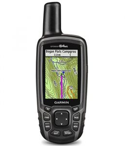
Garmin GPSMAP 64st — $289
This is a functional and affordable option for folks who are looking to get out into the woods, and truth be told, it’s hard to go wrong with any of the models in the 64 series. The GPSMAP 64st features a 2.6-inch sunlight-readable color screen and a high-sensitivity GPS and GLONASS receiver with a quad helix antenna for superior reception. GPSMAP 64st includes a 3-axis electronic compass with barometric altimeter, wireless connectivity and preloaded TOPO U.S. 100K maps plus a 1-year BirdsEye Satellite Imagery subscription. This is the GPS unit that’s clipped to my pack right now, and it does particularly better than older Garmin models in heavy canopy cover.
Features
- Sunlight Readable 2.6 inches color display. Display size : 1.43 x 2.15 inches and 2.6 inch diag (6.6 centimeter). Battery life : 16 hours. Water rating IPX7
- Expanded Internal Memory 8GB.Display resolution 160 x 240 pixels. Interface: high speed USB and NMEA 0183 compatible
- DUAL BATTERY SYSTEM Use with 2 traditional AA batteries (best with Polaroid AA batteries), or the optional rechargeable NiMH battery pack that can be charged while inside the device.Weight 8.1 ounce (230 grams) with batteries
- Receive Smart Notifications and pair with optional ANT+ sensors, such as heart rate monitor, Tempe temperature sensor, speed/cadence, or use to control your VIRB action camera (64s/64st only)
- Wirelessly upload data to Garmin Connect and view on smartphone, plus share activities as they happen with Live Track. 3 axis compass with barometric altimeter.

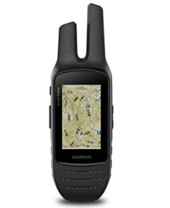
Garmin Rino 755t 2-Way Radio/GPS Navigator — $539.99
Combining map-guided trail navigation with two-way radio communication, the Rino and 755t handheld brings a whole new level of confidence to outdoor adventures. This model, along with the similar 750, features a unique position reporting capability that lets you send your exact location to other Rino users so they can see it on their map displays.
Features
- 5 W GMRS two-way radio offers extended range, up to 20 miles; communicate by voice or unit-to-unit text messaging
- High-sensitivity GPS and GLONASS satellite reception; tracks in more challenging environments than GPS alone
- Position reporting feature shows locations of other Rino users on the same channel
- 3” sunlight-readable touchscreen with dual orientation (landscape or portrait view)
- Dual battery system provides up to 14 hours between charges on lithium-ion pack or up to 18 hours with optional AA batteries (sold separately)
- Rino 755t adds preloaded TOPO U.S. 100K maps and 8-megapixel autofocus camera with LED flash/torch
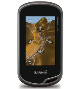
Garmin Oregon 650t — $259.99
From the moment you cradle the 650t in your hand, you’re ready to enter into a new world of Garmin GPS mapping and positioning. With high-sensitivity GPS and GLONASS satellite tracking (more satellites mean faster fixes, even in challenging environments), preloaded TOPO U.S. 100K maps, worldwide basemap with shaded relief and a faster processor, you don’t just look at maps, you interact with them. Zoom in, pan out and rotate using multi-touch. The touchscreen even is compatible with many gloves. The reflective display technology boosts touchscreen brightness so much that maps and displays are as vivid in full bright sunlight as they are in shade. Additionally, now you don’t have to take an additional camera with you to take quality photos. Oregon 650t’s built in 8 megapixel autofocus digital camera takes photos worthy of sharing. And each photo is geotagged with the location of where it was taken, allowing you to navigate back to that exact spot in the future.
Features
- 3-Inch sunlight-readable, touchscreen display with multi-touch capability
- Dual-band GPS/GLONASS satellite positioning
- Sensors (3-axis compass, accelerometer, barometric altimeter)
- ANT or Bluetooth technology -wirelessly share routes, tracks, waypoints, geocaches, custom maps and photos between units Dual orientation – auto switching between landscape or portrait views
- Dual battery system -2 AA batteries or NiMH battery pack charged by the Oregon (battery pack included with 650/650t; optional with 600/600t) 8MP autofocus camera (650, 650t only) with LED flash/torch and digital zoom
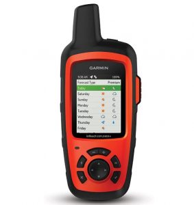
Garmin in Reach Explorer+ — $443.98
Explore anywhere. Communicate everywhere. inReach Explorer+ is the satellite communicator and GPS navigator that uses 100% global Iridium coverage for 2-way messaging, tracking and interactive SOS from anywhere in the world.
Features
- 100% global Iridium satellite coverage enables 2-way text messaging from anywhere (satellite subscription required).
- Trigger an interactive SOS to the 24/7 search and rescue monitoring center.
- Track and share your location with family and friends.
- Pair with mobile devices using the free Earthmate app for access to downloadable maps, U.S. NOAA charts, color aerial imagery and more.
- inReach Explorer+ device adds preloaded DeLorme TOPO maps with onscreen GPS routing plus built-in digital compass, barometric altimeter and accelerometer.