Your Privacy Choices
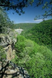
Hiking in the upper Buffalo National River can be your Arkansas ‘Walk in the Woods’. Whether its spring, summer, fall or winter, the adventurous trails along the upper Buffalo National River are perfect for hiking. It is especially beautiful this time of year with spring foliage blossoming everywhere you turn.
Gorgeous vistas and plentiful waterfalls are all waiting to be enjoyed and photographed. This is a wonderful time to be in the woods with crystal clear skies and the blooming trees, creating magnificent vistas for as far as one can see. The upper Buffalo Region is one of the best places to see in the Ozarks. Just remember that April, May and June create spring rains and sometimes extremely high temperatures so plan ahead. Bring snacks and plenty of water on your hike.
Here are some of the best hikes in this writer’s opinion. Many other trails exist and are too numerous to list all of them.
Hawksbill Crag or Whitaker Point Trail may just be the most recognized and photographed spot in the Buffalo National River area. Located south of Harrison, the Crag can be reached off Arkansas Highway 21, south of the communities of Ponca and Boxley. You’ll travel through the Boxley Valley and turn right onto Cave Mountain Road (gravel and dirt), heading straight up the mountain. The road is located just before you cross the Buffalo River on Highway 21. The trail was actually built and is maintained by the National Forest Service. The 3 mile roundtrip hike is fairly easy going in, but a bit harder coming out. Park in the lot at the start of the trail. Some of this is private property, so watch for the signs. This is a relatively easy hike as both older adults and young children always enjoy it throughout the year.
Lost Valley Trail is located just off Arkansas Highway 43 between the communities of Ponca and Boxley. Lost Valley was once an Arkansas State Park that was deeded over to the National Park Service shortly after the Buffalo River was designated America’s first national river in 1972. The trail is 2.3 miles round trip. This out and back trail begins at the campground where picnic and restroom facilities are available and progresses slightly uphill following Clark Creek on the right. The first part of the hike is on a wide, mostly open stretch that is deemed handicap accessible. When you get to the .7 mile mark, the trail will split. Follow the signs to take the trail to the right.
Further up the trail you will see what is typically called the “Jigsaw Blocks”, which is a series of boulders that look as if they fell from the bluff behind them. Continue up the trail where you will come to the lower section of Eden Falls and a huge natural shelter used in the past by Indians. Take the next two right forks until you get to a tall bluff and the entrance to Cobb Cave (approximately 1 mile). This is one of those unforgettable views along the trail. At the end of this stop is the beginning of Eden Falls, another of the great viewing places along the trail. If you are really adventurous, the creek flows out of a cave at the top of the ridge where you can go inside and view another small waterfall inside the cave. This is a really neat adventure but you will need a flashlight and it is somewhat challenging and not recommended for children or the elderly. Remember to take the right side forks as you return to the campground. This trail is rated easy and great for children of all ages, except for the cave section. It is both handicap and stroller accessible for part of the way.
Ponds Loop Trail (.4 of a mile). The trail starts just across the road from the Cedar Grove picnic area on the Erbie Road offering a nice view of the river below. Park in the lot as the trail begins there. To the left is a hard packed gravel trail that is accessible for both strollers and wheelchairs. Within a short distance, you will come to a nice observation deck overlooking the South Pond. From there the trail narrows (not accessible for either children’s strollers or wheelchairs) and heads up into the woods. Turn right when you get to the North Pond and hike back to the parking lot. Incidentally, the 37 mile Buffalo River Trail passes through the picnic area. Both ponds are clear and full of floral and other aquatic plants and animals.
The Buffalo River Trail on the upper stretches is divided into four parts.
South Boxley to Ponca (11 miles)
Ponca to Kyles Landing (passing Steel Creek campground) (9.9 miles)
Kyles to Erbie (7.5 miles)
Erbie to Pruitt (passing Ozark campground) (8.7 miles)
Total 37.1 miles
Each of these hikes along the Buffalo River Trail offer something special. Whether its high vista-views of the river or mountains, old abandoned farmsteads, waterfalls or native wildlife, the trails are there for your enjoyment. The trails can be hiked all at once or singularly. There are entry and exit points on each of these trails. You will cross numerous creeks along this route. (Pay attention to the weather as these creeks can rise rapidly during heavy rain.) Camping is allowed along these trails. For more detailed information and maps of these hikes, contact the Buffalo National River headquarters in Harrison at 870-741-5443 or visit their web site at www.nps.gov.
Some of these hikes are not designed specifically for young hikers, but offer features suitable for others. However, many are excellent when introducing young people to the outdoors. For additional information on these or other trails along the upper Buffalo National River, contact the Harrison Convention and Visitors Bureau at 1-870-741-1789, toll free at 1-888-283-2163 or log on to their web site at www.harrisonarkansas.org.