Your Privacy Choices
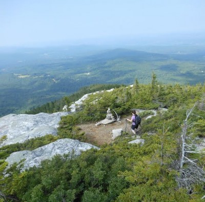
Black Mountain ledges.
Sometimes big things come in small packages.
The low-lying Benton Range in New Hampshire’s White Mountains is comprised of a half dozen mountains all under 3,000 feet in elevation. The highest is Jeffers Mountain at 2,994 feet with Owls Head being the lowest at 1,967 feet. In between are Black Mountain (2,830 feet), Sugarloaf (2,609 feet), the Hogsback (2,810 feet), and Blueberry Mountain (2,662 feet).
Black and Blueberry mountains are the only pinnacles with maintained trails. Both contain ledges with outstanding views. Certainly time is well-spent at both locations, and since they’re only about a 15-20 minute drive apart, it’s possible to do the pair in the same day for about eight miles of fine White Mountain hiking.
A double dose of those Benton mountains yields outstanding vistas and surprises from wonderful glimpses upon Mount Moosilauke from Blueberry’s ledges to a slight diversion from Black’s Chippewa Trail to historic kilns used to make lime.
The day began off bucolic Lime Kiln Road near Benton with the 1.9-mile hike up Black Mountain to the incredible ledges overlooking a land containing the Connecticut River Valley and beyond.
The stiff climb includes passage through an enchanting red pine grove in the Society for the Protection of New Hampshire Forest’s Kingsbury-Chippewa Trail Forest.
The ledges were soon plentiful along the twisting path before the summit crest with its many vantage points. A fire tower once stood on those ledges, first built in 1911. How incredible it must have been to peer through binoculars at Moosilauke in the southeast, Vermont in the west, and the rest of the stunning landscape.
On the way down, a short diversion along a logging road led us to the impressive Black Mountain Kilns used to burn limestone into the versatile mineral lime. One of the kilns is some 20 feet high, and they were last used in 1888. The flames reached 1200 degrees, and the lime was stored in casks for transport.
On the southern end of the range, Blueberry Mountain (yes, there were some for the picking) is clearly the easier of the two hikes—a 1.7-mile one-way jaunt along the Blueberry Mountain Trail from Long Pond by Glencliff, but the curious summit with its metal pins isn’t the greatest prize—it’s the myriad of ledges shy of the top.
There has been a lot of logging in the area. The plus side is a pleasant Moosilauke view fairly early on in the hike.

The kilns.
But there’s a big of bafflement in the fresh mountain bike tracks found along the narrow singletrack-like path through the pines and along the ledges. It wasn’t until later that the aha moment came thanks to an early Pemigewasset Ranger District White Mountain National Forest Mountain Bike Map from 1992 that was unearthed at home.
A benign excursion for hikers, the trail was an expert rated pioneering pathway for mountain bikers who now have far better White Mountain trails to pedal.
But both can do some picking on Blueberry Mountain, the peak aptly named. Before that though, my wife Jan and I had some bewildering moments trying to figure out the summit. A large rock cairn on the trail seemed to be it. No views there. We pressed on a short time and were rewarded with some outstanding views to the west. It wasn’t until the return that we noticed we had missed a turn and there we scrambled to the summit with its Mount Carr and Cardigan (reached by a side path) vistas above the trees and iron pieces embedded in stone.
Though we didn’t see anything to indicate it was there, the Dartmouth Outing Club once had a shelter near the peak’s summit that was removed some 70-plus years ago.
The beauty of Blueberry was now in lingering, and we took our time during the descent, particularly by those stunning ledges with its feint unofficial trails leading off to various view points, excellent places that make standard PB&J sandwiches taste better for some reason.
With the temperature approaching 90, we were thankful for a welcoming breeze. Heading down, time was spent looking ahead to the wondrous horizon and looking down to make sure the feet were hitting stride, a task not all that simple to do.
Once the logging areas were reached, we stopped to take in one last look at marvelous Moosilauke, a mountain you see much of while bopping about on Black and Blueberry mountains in the Benton Range.
Images by Marty Basch